Finwaver.com
Your school or business runs better on finwaver.com. Sign up for free one (1) week try.
1.
A long narrow stretch of hills is called
Ridge
Spur
Mountain
Valley
2.
Bugum is a festival of the
Dagomba
Nanumba
Mamprusi
Sisala
3.
A line drawn on maps to show places of equal height above sea level is
a contour
an isotherm
a latitude
an isobar
4.
In which of the following regions in Ghana is the Boti Falls?
Ashanti
Eastern
Western
Central
5.
Alluvial gold is found in
River Oti
River Offin
River Densu
River Bia
6.
Ghana's Earth satellite station is at
Nsawam
Koforidua
Ada
Kuntunse
7.
Which of the following shows the relationship between distance on paper and actual distance on the ground?
Longitude
Key
Scale
Plan
8.
The Greenwich Meridian passes through
Tema
Accra
Takoradi
Kumasi
9.
Which of the following rivers flows into Lake Volta?
Tano
Afram
Pra
Bia
10.
Which of the following trees is not used as Timber?
Wawa
Odum
Sapele
Nim
11.
What does the conventional sign on Ghana topographical maps stand for
Fort
Court house
Mosque
Zongo
12.
Which of the following is not found in West Africa?
Fouta Djallon Mountains
Guinea highlands
Jos Plateau
Akwapim-Togo Ranges
13.
Which of the following is not a feature of relief?
Plain
Plateau
Inselberg
River
14.
If it is 12 noon at longitude 0°. What will be the time at a place which lies on longitude 15° E?
12:15 am
1:00 am
11:00 am
12:15 pm
15.
Which of the following is not a latitude?
Equator
International Date Line
Tropic of Cancer
Tropic of Capricorn
16.
An example of an igneous rock is
Granite
Sandstone
Gneiss
Shale
17.
Which of the following features is not associated with rivers?
Delta
Waterfalls
Ria
Meander
18.
Rotation of the earth causes
Day and night
Seasons
Eclipses
Equinoxes
19.
Which of the following minerals is not mined in Ghana?
Gold
Tin
Diamond
Manganese
20.
Alumina is obtained from
gold
diamond
manganese
bauxite
21.
In Ghana deep shaft mining is generally associated with
gold
salt
bauxite
diamond
22.
The earth rotates on its axis, spinning from
east to west
west to east
south to north
west to south
23.
Which of the following is not an irrigation farming area in West Africa?
Inland Niger Delta
Sokoto River Valley
Accra Plains
Richard Toll District
24.
Which of the following countries in West Africa is a major exporter of groundnuts?
Senegal
Ghana
La Cote d'Ivoire
Liberia
25.
Which of the following countries introduced Indirect Rule in her colonies in West Africa?
France
Britain
Portugal
Germany
26.
The president of the Aborigine Rights Protection Society was
John Sey
James Kwegyir Aggrey
John Mensah Sarbah
Sir Arku Korsah
27.
An imaginary line which divides the earth into two hemispheres is called the
latitude
longitude
meridian
equator
28.
At the Berlin Conference of 1884-85 the Europeans agreed on how to
divide Africa among themselves
spread Christianity in Africa
trade with the Africans
tax the Africans
29.
An example of a sedimentary rock is
granite
gneiss
marble
clay
30.
The world's largest producer of cocoa is
Brazil
La Cote d'Ivoire
Ghana
Argentina
31.
Which of the following is a tertiary occupation?
Wood Cutting
Manufacturing
Quarrying
Teaching
32.
The original home of the Ewe was
Ho
Keta
Ketu
Kpando
33.
Which of the following conducted the District Assembly Election in Ghana?
National Commission for Democracy
National Council on Women and Development
Statistical Services Department
34.
The bond of 1844 was signed between
Commander Hill and Fante chiefs
Captain George Maclean and Ashanti chiefs
Commander Hill and Northern Chiefs
Captain George Maclean and Fante Chiefs
35.
Which of the following crops would not thrive well in the Savanna?
Millet
Coffee
Shea nut
Rice
36.
The longest river in West Africa is
River Senegal
River Volta
River Niger
River Gambia
37.
Use the bar graph below to answer the question below
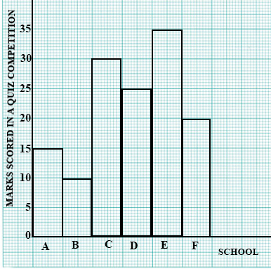
Which school scored the lowest mark?
School A
School B
School C
School D
38.
Use the bar graph below to answer the question below
What was the total mark scored by School C?
25
30
35
42
39.
Use the bar graph below to answer the question below
Which school won the competition?
School A
School B
School C
School D
40.
When the republic of Liberia attained independence the people of Liberia adopted the motto
One Nation, One People, One Destiny
Freedom and Justice
Unity and Strength
Unity and Faith
a)
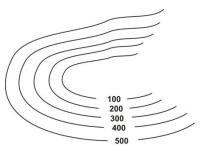
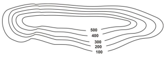
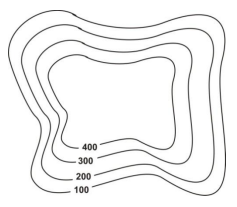
Write notes on contours and illustrate with diagrams
i)
a valley
ii)
a ridge
iii)
plateau
iv)
conical hill
b)
How are the following features shown on topographical maps
i)
railway line
ii)
a bridge
iii)
farm
iv)
footpath
v)
an area liable to flood
Use the map below to answer the Question below
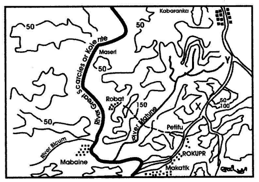
a)
i)
What is the name of the major river shown on the map?
ii)
What is the main tributary of this river?
b)
i)
Measure the distance from X to Y in kilometers (Scale = 1cm : 2km)
ii)
Which type of road is from Rokupr to Kabaranka?
c)
i)
Which type of settlement is at Kabaranka?
ii)
What is the height of Maseri in feet?
What are the importance of festivals in Ghana?
Write an essay on one of the following:
a)
The achievements of Dr Kwame Nkrumah
b)
The achievements of Sir Gordon Guggisberg
What four major benefits do West Africans derive from their rivers? Give specific examples where necessary.
Problems facing the Organization of African Unity (OAU)


Digital Address: GZ-033-0057
King Kotey Road
Teshie - Accra
Ghana
+233 54 753 9118
info@kuulchat.com
![]()
© Copyright 2015 - 2026
All Rights Reserved